Last updated: Thursday 18 June 2026
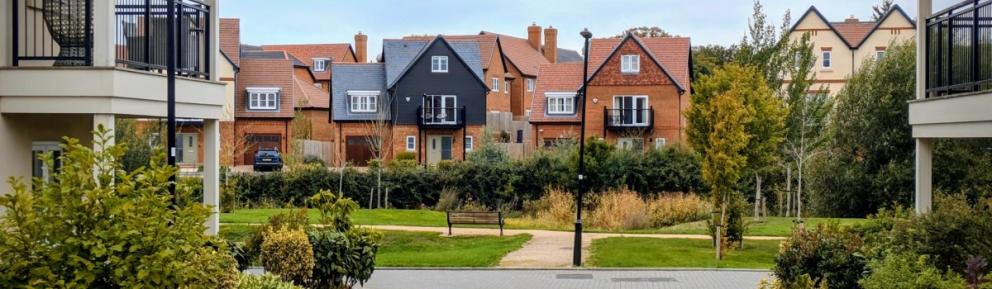
This page gives an overview of planned and ongoing development in Warfield. It includes information on housing, infrastructure and services across 4 development areas.
At the bottom of the page is a section on key information. This covers topics such as GP and primary school provision, green spaces, shops and how to comment on planning applications.
Overview
Land in Warfield has been identified for a large mixed-use development (Policy SA9 of the Site Allocations Local Plan).
The development will include new homes as well as supporting infrastructure and community services.
In 2012, the council adopted a Supplementary Planning Document (SPD) to guide this development.
The SPD sets out what is expected from developers and how the area should be planned. All planning applications for this site are assessed against this guidance.
| Attachment | Size |
|---|---|
| 9 MB |
The site has been divided into:
- 4 areas of residential-led, mixed use development (Areas 1 to 4)
- an area allocated for SANG delivery (Area A)
These areas are shown on the map below.
| Attachment | Size |
|---|---|
Document
Delivery plan
|
229 KB |
On this page, we provide more information about each area, including:
- masterplans
- approved plans
- planning permissions
You can also view approved permissions and applications currently under consideration on the planning portal.
Area 1
The master plan below shows that Area 1 is made up of several sites centred around Newell Green.
| Attachment | Size |
|---|---|
Document
Area 1 masterplan
|
14 MB |
The document below shows a map of Area 1 broken down into planning permission zones.
| Attachment | Size |
|---|---|
Document
Area 1 permissions map
|
460 KB |
The development of Area 1 includes:
- approximately 600 new homes
- land safeguarded for a new primary school
- public open spaces
- east–west greenway
- two new roundabouts
- a community hub
- a neighbourhood centre with local shops
Details of the relevant planning permissions for Area 1 are listed below.
116 dwellings:
- minor amendments under application reference 18/01047/FUL
- minor amendments under application reference 23/00660/FUL
52 dwellings:
- minor amendments under reference 19/00157/FUL
43 dwellings.
9 dwellings.
7 dwellings.
1 dwelling.
Outline permission for up to 305 dwellings, a primary school, open space and associated works:
- 22/00314/REM – parcel 4 of permission 20/00214/OUT (45 dwellings)
- 22/00578/REM – parcel 3 of permission 20/00214/OUT (175 dwellings)
- 22/00787/REM – parcel 1 of permission 20/00214/OUT (12 dwellings)
- 24/00683/REM – parcel 2 of permission 20/00214/OUT (27 dwellings)
43 dwellings.
Includes:
- 2 new roundabouts
- new neighbourhood centre, including shops
- up to 150 dwellings
1 dwelling.
16 dwellings.
New community hub building including:
- café
- flexible multi-use spaces
- sports hall
- dance and fitness studio
- meeting rooms
- new offices for Warfield Parish Council
- children's play area
- enhancements to existing sports pitches
- provision of greenway and bridleway connections
Area 2
This site was built in 10 phases and is now fully completed.
The master plan below shows that Area 2 is located between Harvest Ride, Forest Road and Avery Lane.
| Attachment | Size |
|---|---|
Document
Area 2 master plan
|
10 MB |
The document below shows a map of Area 2 broken down into planning permission zones.
| Attachment | Size |
|---|---|
Document
Area 2 permissions
|
380 KB |
The development of Area 2 includes:
- approximately 800 new homes
- public open spaces
- a new primary school
- Suitable Alternative Natural Greenspace (SANG)
- a new link road
- an east–west greenway
- other facilities such as play areas
Details of the relevant planning permissions for Area 2 are listed below.
This development consists of up to:
- 750 dwellings
- senior living scheme
- primary school
- north-south link road
- river park
Permissions relating to this development are:
- 14/01275/REM - details in relation to a primary school (including nursery) and playing fields
- 15/00144/REM - details in relation to a SANG
- 15/00163/REM - details in relation to 93 dwellings
- 15/00217/REM and 18/01197/REM - details in relation to The Cut river park
- 15/00646/REM - details in relation to 65 dwellings for senior living
- 15/00647/REM - details in relation to 58 dwellings
- 15/00908/REM - details in relation to East-West Greenway and 2 play areas
- 16/00515/REM - details in relation to 93 dwellings
- 16/01041/REM - details in relation to landscaping
- 16/01123/REM - details in relation to 49 dwellings
- 17/00054/REM - details in relation to 121 dwellings
- 17/01383/REM - details in relation to allotments and community hub
- 18/00396/REM - details in relation to 157 dwellings
- 20/00265/REM - details in relation to 120 dwellings
39 dwellings.
Area 3
The master plan for Area 3 is in development. It is anticipated that it will be agreed upon in summer 2026.
Plans for this area include:
- approximately 450 dwellings
- the creation of a River Park along the Bull Brook
- road junction enhancements
- the continuation of the east-west greenway
Area 4
Area 4 is a small parcel of land opposite Jock’s Lane. It does not require a master plan.
Planning permission for the scheme was granted under reference 13/00831/FUL.
The development consists of 27 dwellings and is now fully completed and occupied. It has the street name ‘Elen Place’.
Area A - Suitable Alternative Natural Greenspace
Suitable Alternative Natural Greenspace (SANG) is a green space open to public access. It is designed to provide attractive areas for recreation, helping to reduce visitor pressure on nearby Special Protection Areas (SPAs).
SANG has been provided at Cabbage Hill, providing 34 acres of publicly accessible open space.
It has been approved under planning reference 15/00144/REM.
Key Infrastructure
Community hub
The community hub, to be delivered at Priory Field, was approved under planning reference 25/00703/3.
It will include:
- a café serving food and drinks throughout the day
- multi-use spaces for hire
- a large sports hall suitable for various activities
- a modern dance and fitness studio
- bookable meeting rooms
- enhanced sports pitches at Priory Field
- a new children’s play area
- improved greenway and bridleway routes for walking, cycling and horse riding
- car parking and cycle stands
- a new base for Warfield Parish Council
Neighbourhood centre
A neighbourhood centre, including a small parade of shops, was approved under planning reference 22/00150/OUT.
Primary school
Area 2 contains a primary school, approved under planning reference 14/01275/REM, opened in 2016.
Land has been safeguarded for the delivery of a new primary school under planning reference 20/00214/OUT. It will be built if needed.
East-West Greenway
The Greenway is a pedestrian, cycle and sometimes horse-friendly route running the length of the development. It connects the recreation areas of Jocks Lane in the west to Westmorland Park in the east. As well as offering a pleasant route for people, greenways can also provide a habitat corridor for plants, birds, animals and insects.
Allotments
The Quelm Allotment site, off Sopwith Road, has been created in Area 2. It contains 54 plots and is managed by Warfield Parish Council.
River parks
A river park is a green space located alongside a river, designed for both people and nature. These areas balance environmental protection with opportunities for relaxation and recreation.
A river park alongside The Cut River has been created in Area 2. A river park alongside The Bull Brook is proposed in Area 3.
Sports pavilion
Upgrades to Warfield Memorial Ground have been proposed. Proposals include replacing the sports pavilion and improving the playing surfaces.
GP’s surgery
The Integrated Care Board (ICB) helps make sure local people can access GP services and other healthcare. It has been involved in planning for the Warfield development and is working to improve and expand primary care across the area.
Residents of the new Warfield community will be supported by nearby healthcare facilities.
These will include:
- the relocated NHS Binfield Surgery
- new NHS facility in Bracknell Town Centre, which received planning permission in 2024
End of construction
The Warfield area is a large and evolving development. Building work is expected to continue over the next 10 years or more.
As different parts are completed at different times, some construction activity will remain ongoing across the wider site.
Current status of construction:
- Area 1 - planning permission has largely been granted, but there is still a significant amount of development to be completed
- Area 2 - most of the area is now built-out, although a small number of additional sites may be developed in future
- Area 3 - a master plan is currently being prepared and once in place, planning applications will begin to come forward
- Area 4 is now fully completed
How to comment, support or object to a planning application
To comment, support or object to a planning application you can:
- use the public planning portal
- email your feedback to development.control@bracknell-forest.gov.uk
You must include:
- your name
- full address
- the reference number of the application
If you do not include these details, your comments might not be considered.
Supporting documents
View the documents below for more information.