Improving our rights of way

This page provides a summary of findings from a review of our Rights of Way Improvement Plan.  

Review purpose

We conducted the review halfway through the 10-year plan.

The purpose of the mid-term review is to assess how well we are achieving our targets and actions.

It also allows us to re-evaluate the agreed priorities for the rest of the plan.


pie chart - progress

Progress

The review was completed in January 2023. 

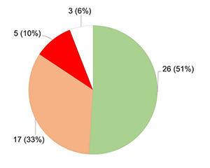
At that time, of the 51 targets set for action between 2017 and 2027:

  • 26 (51%) had been fulfilled or were on target for completion
  • 17 (33%) had made progress but need some attention to meet the target
  • 5 (10%) had stalled or risk not being met by 2027
  • 3 (6%) were either no longer relevant or are to be discontinued
pie chart - type of improvement

Type of improvement

Over the last 5 years, we've been working hard to deliver improvements to our public rights of way. Overall, we have made:

  • 35 furniture improvements (43%)
  • 29 surface improvements (35%)
  • 9 major vegetation works (11%)
  • 7 new signs (9%)
  • 2 new bollards (2%)

Replacing stiles

The biggest improvements to access have been replacing stiles with accessible gates or removing them altogether. This is listed above as furniture improvements.

Only one footpath now has traditional stiles.

New paths

The length of the rights of way network increased in 2023 with 2 new paths and a diversion in Sandhurst:

  • footpath 26 has added 86 metres
  • footpath 27 has added 215 metres
  • footpath 9A diversion has added 370 metres

In total we have 82km of rights of way paths.

How we work with our partners

The Local Countryside Access Forum (LCAF)  advise the council rights of way team on where stiles cause an issue for access. 

We liaise with the landowners who are responsible for the furniture, to arrange permission for the improvements. 

We also work with volunteers from the Bracknell Conservation Volunteers to deliver the physical improvements. 

The South East Berkshire Ramblers often fund the smaller projects.

We are very grateful to all the volunteers that work so hard to help us improve our rights of way. 

Accessible rural route guides

Wooded walkway in Cabbage Hill

Action

Review and update the 3 Accessible Rural Route guides.

Outcome

First new walking route guide published on our website in winter 2022.

See the Cabbage Hill and The Cut Circuit route guide.

Benefits to residents

The new 3.3 miles (5.3 km) circular route takes in attractive countryside of Cabbage Hill and The Cut river. It follows historic Quelm Lane on its eastern stretch.

The route was devised by volunteers (LCAF) with our help, to provide an accessible walk to residents. It follows surfaced paths and has no stiles. 

For shorter walks that follow surfaced paths, see our sites at:

Signs that promote sharing

Sign: share the trail

Action

New routes or improvements to existing routes should be designed to minimise conflict.

Outcome

The Trail Rider's Fellowship led the way for us to develop new 'share the trail' signs. They were installed at these Bracknell Forest byways:

  • Penfurzen Lane
  • Hogoak Lane
  • Snipes Lane
  • Hawthorn Lane
  • Berry Lane

Benefits to residents

The purpose of the new signs is to encourage responsible and courteous use of the byways by all users. This includes horse riders, trail riders, walkers, horse-drawn carriages, motor vehicles and cyclists.